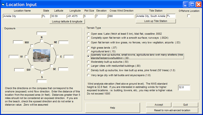
Advanced Wind Estimation Data Entry (Legacy)
Data entry on this form should be considered with extreme care as it can result in lowering the estimated wind speeds significantly for this location on all reports.
The
following is the legacy / prior AWE data entry form.
It is included to support the prior version’s AWE capability.
Usage of this form and filling in exposure and terrain type information requires
an excellent knowledge of the locations environment.
Changing either of these values will have a significant affect on calculated
wind speeds.

This option allows the user to enter "advanced" information about locations. Locations can be anything that have latitude and longitude and size attributes. I.E. A city, island, point, lighthouse, etc.. Remember western longitudes are negative while eastern longitudes are positive.
Location Name - This identifies the location's name
State - This identifies the location's state or country code (2 or 3 digits)
Latitude - This identifies the location's latitude in decimal degrees. All latitudes north of the equator are positive and those south are negative. Latitudes for the North Atlantic and Eastern Pacific are positive. NOTE: DO NOT USE DEGREES AND MINUTES. To convert degrees/minutes to degrees and tenths of a degree, take the number of minutes, divide by 60 and add it to the degree value. I.E. 29 degrees 36 minutes is 29.6 degrees.
Longitude - This identifies the location's longitude in decimal degrees. All Western longitudes are negative while all Eastern longitudes are positive. Longitude values for the Atlantic and Eastern Pacific locations are negative. NOTE: DO NOT USE DEGREES AND MINUTES. To convert degrees/minutes to degrees and tenths of a degree, take the number of minutes, divide by 60 and add it to the degree value. I.E. -78 degrees 54 minutes is -78.9 degrees.
Plot Size - This represents the circular size of this location. This can range anywhere from 0 to 100 nautical miles. A zero value will not draw any circle, thus being well suited for geographical landmarks like points, bays, etc.. Other values will draw circles or points depending on the size of the location and size of the map they are plotted on.
Elevation – This indicates the location’s elevation above mean sea level in feet. It is only used by the SLOSH report function and supercedes the elevation calculated by the DEM (digital elevation model) data included with the system.
Cross Wind/Flood Direction - This identifies either the direction of the cross wind across a runway (for example) or if used in the flood index for a location, the direction that flooding typically occurs from. For information on how this is used in runway crosswind analysis, see Cross Wind calculation setup and use. In the example for storm surge flooding... in Miami a direct East wind (090 degrees) is the direction that flooding occurs. In Panama City, FL, the direction is more like SSW or 200 degrees. This is used in the detail location reports when calculating onshore wind flow and also the location report flood index graph.
Tide Station - This identifies the tide station associated with this location. To associate a location to a tide station, click on the "Look up Tide Station" option. The user will then be presented with a tide station selection window.
Offshore Location - This identifies the location as a fixed offshore location, such as an oil platform, etc.. When checked the system will include wave height calculations in the summary and detailed impact report for this location
Exposure - This is an important data element. It describes the exposures that are characteristic for this location. For each of the 8 compass directions where there is an open exposure within 5 miles, the user should mark that direction as well as indicate (in feet) the distance from that exposure. Open exposures include large lakes (> 3 miles) or ocean/sea areas. In the example above, we are describing a location that has an open ocean exposure nearby to the east (500 feet) and less of an exposure in other directions (N, S, NE, SE). All western directions are not exposed. This value has an impact on the wind speeds estimated by Advanced Wind Estimation.
Terrain Type - This is also an important data field. It describes the frictional characteristics of the location's area. The user should select the option that best describes the location's environment. It is highly suggested that the user initially "under value" frictional (lower friction) considerations until experience indicates otherwise. This value has a large impact on the estimated wind speeds calculated by Advanced Wind Estimation.
Wind Analysis Elevation - Not to be confused with the location's elevation above sea level. This value indicates the elevation above ground level that the user would like used in by Advanced Wind Estimation. A standard of 10 meters is the default, however you can change this from 5 to 999 feet AGL.
The options available from here are:
To
lookup a location's
latitude and longitude,
select the Lookup
Latitude and Longitude option.
To associate a
location to a tide station,
select the "Look
up Tide Station" option.
To accept the changes, selection the "Accept" option.
To reject all changes, select the "Quit" option.
To clear all advanced location data for this location, select the "Reset to non-advanced location", option. This will clear all exposure and terrain type information for this location.